The Great Divide: Caribbean Calm vs. Atlantic Power
To understand the hydrology of Barbados is to understand an island of two distinct personalities. While the island is often marketed as a monolithic tropical paradise, its 60-mile coastline is split between two vastly different bodies of water. The geological backbone of the island acts as a literal shield, creating a serene environment on the leeward side and a volatile, high-energy theatre on the windward side. For any visitor planning a trip to Bathsheba and the Soup Bowl, acknowledging this shift is not merely a matter of geography—it is a critical safety requirement.
The West Coast: Caribbean Calm
The western shoreline of Barbados, bordering the Caribbean Sea, is characterised by its tranquil, turquoise waters and sandy floor. It is the premier destination for swimming, snorkelling, and leisure, as seen in the calm bays of Holetown. Here, the water acts as a gentle mirror, offering predictable conditions for families and casual visitors. The shelf gradient is gradual, and the wave energy is typically negligible, making it the “safe” side of the island for traditional recreation.
The East Coast: Atlantic Power
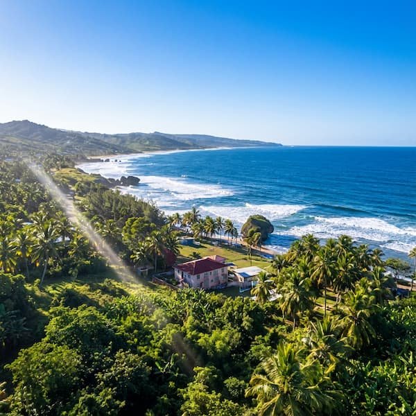
In contrast, the East Coast is battered by the raw power of the Atlantic Ocean. This is a high-energy environment where cobalt depths meet the rugged limestone of St. Joseph. Visitors must shift from a “swimming-friendly” mindset to one of respect and observation, as the hydrological forces here are fundamentally different and significantly more volatile. The water is moving constantly, driven by thousands of miles of fetch that begins as far away as the African coast.
The “White Water” Trap: Aeration and Buoyancy Loss
One of the most invisible and misunderstood dangers at Bathsheba and the Soup Bowl is the physics of aerated water. When massive Atlantic waves crash against the shoreline, they do not just move water; they trap millions of microscopic air bubbles, creating the thick, white foam that gives the area its name. While this “soup” of bubbles is visually stunning and a favourite for photographers, it creates a deadly physical hazard by significantly reducing the density of the water.
Even expert swimmers struggle in aerated water; because the water is less dense, your body loses its natural buoyancy, making it nearly impossible to keep your head above the surface.
In “green” water, your body displaces enough weight to float easily. In the “white water” of the East Coast, the ratio of air to water is so high that you effectively sink. Standard treading water techniques fail because there is no solid medium to push against. This “white water” trap is the primary reason why the open ocean at Bathsheba is strictly reserved for expert surfers who are equipped with boards for flotation. For anyone else, even a shallow entry into the surf zone can lead to an immediate struggle to remain upright or breathe.
The Tabletop Reef Shelf: A Geological Hazard
The underwater landscape of the East Coast is defined by an abrupt coral limestone shelf that functions as a geological tripwire. Unlike the gradual, sandy slopes found on the West Coast, the geology here—closely linked to the Mushroom Rock formations—creates extreme vertical volatility. The ocean floor can drop or rise by 6 feet (1.8 metres) instantaneously, which dictates the violent way the waves “pitch” and break at the Soup Bowl.
During low tide, this shelf sits just 1.5 to 3 feet below the surface. This shallow depth creates a high risk of “reef rash”—severe abrasions and impact injuries caused by being thrown against the sharp, fossilised coral by a breaking wave. For surfers, this means a fall often results in contact with the ground. For waders, an unexpected surge can sweep your feet from under you, dragging you across the abrasive limestone. For more on navigating this rugged terrain safely, see our guide on Visitor Logistics.
Understanding Warning Flags & Conditions
Before heading to the beach, it is vital to understand the local warning flag system used by the Barbados National Conservation Commission (NCC). While the East Coast is rarely “safe” for swimming, these flags provide essential context for the level of risk on any given day.
| Flag Colour | Meaning | Safety Recommendation |
|---|---|---|
| Red | High Danger | No swimming; extremely dangerous currents. Stay well back from the waterline. |
| Yellow | Medium Hazard | Exercise extreme caution; strong undertow present. Suitable for expert surfers only. |
| Green | Low Hazard | Relatively safe, but stay alert for sneaker waves. Rare on the East Coast. |
| Purple | Marine Pests | Stingrays, jellyfish, or Portuguese Man-o-War present in the water. |
North Atlantic Groundswells (November–March)
The most dangerous time for ocean safety on the East Coast coincides with the peak tourist season. From November to March, powerful storm systems moving across the North American coast send massive groundswells south toward Barbados. Unlike local wind-driven waves, groundswells are deep-water energy pulses that can travel thousands of miles. They arrive at Bathsheba as towering walls of water, often on days when the local wind is calm and the sky is clear.
This period is also known for “sneaker waves”—massive sets that arrive without warning after a long period of apparent calm. A tourist standing on a dry rock for a photograph may find themselves engulfed by a wave that is 4 feet higher than the previous twenty. If you are planning a road trip during this time, refer to our East Coast Driving Guide to find elevated vantage points like Cherry Tree Hill, which allow for safe wave watching without entering the splash zone.
Specific Local Hazards: Rips and “Cobblers”
Rip currents at Bathsheba are most common in the “depressions” or darker water channels that run between the iconic Mushroom Rocks. To the untrained eye, these channels look like the safest place to enter because the water appears calmer and waves are not breaking there. In reality, these are the exit points where water pushed shoreward by waves rushes back out to sea at high velocity. If you see a “gap” in the breaking surf where the water looks murky or brownish from churned-up sand, that is a rip current.
Biological hazards are just as prevalent as physical ones. The “inside” section of the Bathsheba pools and the surrounding reef is a primary habitat for Diadema antillarum, known locally as “Cobblers” or long-spined black sea urchins. These creatures nestle in the crevices of the limestone shelf. Entering the water without thick-shelled reef shoes often results in painful stings. Local lore suggests using lime juice or vinegar to dissolve the calcium-based spines if you are stung—a remedy that is scientifically sound but incredibly painful.
Tidal Over-Wash and the “Washing Machine” Effect
While the shallow inshore pools at Bathsheba are often touted as safe soaking zones, they are entirely dependent on the tide. During High Tide or “Spring Tides,” large Atlantic swells can “over-wash” the protective rock barriers. This creates a “washing machine” effect, where water pours into the pool with immense force but has no quick way to exit. This creates turbulent suction that can trap bathers against the sharp inner reef or push them into deep crevices. Always check a local tide chart and aim to visit the pools during the two hours surrounding Low Tide.
Safe Ways to Experience the East Coast
Respecting the Atlantic does not mean avoiding it. The best way to experience the power of the St. Joseph coastline is through guided tours that prioritise safety and local knowledge. Whether you are viewing the coast from a 4×4 or enjoying a meal at the Round House, the majesty of the ocean is best appreciated with a healthy dose of distance.